Tuesday, September 16, 2014

Cardinal Flower –Nectar for Hummingbirds or a Tonic for Lovers?

Cardinal flower and the ruby-throated hummingbird pollinating it.  Love at first sight?
Photo by C. Magnuson (RWMWD).


By Sage Passi

I fell in love with the cardinal flower years ago when we first planted it in Marian Seabold’s rain garden – one of the many home rain gardens we planted years ago. I must not be the only one who is enamored with this bright red flower. I’ve noticed that the landscape designers who consult on our church rain garden designs also have an affinity for this lovely native wet meadow species, as evidenced by its appearance this year in a number of projects I’ve been keeping my eyes on. Its crimson blossoms stand out as September gardens begin to transition to their fall flowers and summer foliage fades. 


Cardinal flower (Lobelia cardinalis) paired with Great Blue Lobelia (Lobelia siphilitica) in
Our Redeemer Lutheran Church Rain Garden.
 
But alas, cardinal flower, like some loves lost, has a habit of disappearing in our gardens after a while. It’s short-lived so you may have to renew your vows to this flower periodically and plant it again if it doesn’t successfully reseed itself.


Cardinal flower stretches out its blooming time to September.  Left to right: July, August, September, November.

Lobelia cardinalis can grow to be two to four feet tall and is related to Lobelia siphilitica (great blue lobelia); both display the characteristic "lip" petal near the opening of the flower and the "milky" liquid the plant excretes. Each flower has three spreading lower petals and two upper petals, all united into a tube at the base. L. siphilitica has blue flowers and is pollinated by bees; whereas L. cardinalis is red and depends upon the ruby-throated hummingbird for its pollination since most insects find it difficult to navigate the long tubular flowers. Occasionally I have run into other forms that are much paler in color. Delving into this a bit further, I discovered that there are indeed other forms including white (f. alba) and pink (f. rosea) so that answers my question as to why I have seen “white” cardinal flowers on occasion.

Cardinal flowers ablaze in Lakeview Lutheran's rain garden.  Note the "white" form (f. alma)
growing in the midst of the others.

So where should you plant it? In the wild I have come upon it on river banks while canoeing along the St. Croix River. It’s happiest growing in wet meadows, stream banks and along lake edges so that explains why it’s also appropriate to rain gardens. But I have been able to successfully establish it in well drained rich loam or sandy loam in drier conditions as well. It seems to adjust to either full sun or shade so this plant seems to be fairly adaptable. Cardinal flower will take two years to bloom, forming a large rosette the first year. Allow the plants to self-sow. They are heavy feeders, so compost or a shot of granular fertilizer when they begin growth is recommended.
 
As I mentioned in a previous plant story, I like to collect plant lore. The common name and its species name (cardinalis) alludes to the bright red robes worn by Roman Catholic cardinals. My research unearthed multiple stories from native tribes and European lore that indicates that this plant has often been used in love potions and cures. The Mesquaki were known to use cardinal flower in love ceremonies. They put chopped up roots into the food of quarreling couples to help them reconcile their differences. The Pawnee used the cardinal flower as a love charm. They believed that possession of the plant made them irresistible to the one they loved. But I warn you, according to some sources, fatal overdoses have resulted from the improper use of this plant as a home remedy so I recommend caution on this note.


Consider adding these vividly colored jewels to your garden’s palette and sit back and wait for the hovering hummingbirds. But be vigilant or, like these aerial artists that they attract, the cardinal flowers may surprise you with their own disappearing act!


Marian Seabold's cardinal flowers accent her East St. Paul rain garden.

Monday, September 15, 2014

What is Atlas 14?

Is the flooding that occurred in the spring of 2014 further evidence that weather is changing, our precipitation
models are inaccurate, or a combination of both?

In 2013 the National Oceanic and Atmospheric Administration (NOAA) released Atlas 14, Volume 8, a tool that revises rainfall/precipitation frequency estimates. The estimates serve as an update to the U.S. Weather Bureau’s Technical Paper No. 40 (TP-40) published in 1961, which has served as a key document over the years for water planners and hydrologists. The Watershed District, which used TP-40 estimates in the past, is in the process of integrating Atlas 14 projections into its next management plan.


Why the change? What is the significance?


Eleven Midwestern states, including Minnesota, recognized that there was room for improvement with the 1961 TP-40 methodology and new technology to support doing so.  They pooled their funds to update this tool. TP-40 used available rainfall information from far fewer stations than exist today and included the “dust‐bowl” years of the 1930’s.  Using many more rainfall collection stations to record rainfall outside of a major drought period allowed for more accurate modeling of current climate patterns.  The maps below show how reporting locations have increased in Atlas 14.


Left: TP40 Daily Stations across MN.  Right: Atlas 14 Daily Stations.  The number of stations in Minnesota where this rainfall frequency data is collected daily. Map images courtesy of BARR Engineering. 
Left: Rainfall stations that recorded sub-daily precipitation amounts for the TP-40 model.  Right: Sub-daily stations used for the Atlas 14 model.  Green dots show stations that record at 1-hour increments, red dots record at 15-minute increments, and yellow dots record at variable increments based on rainfall volumes.

The average record length used in the tool is now over 50 years and doubles the record use in original studies. The oldest Minnesota rainfall dataset dates back to 1836 (Fort Snelling/Minneapolis St. Paul Airport)!

Rainfall frequency or recurrence intervals in Atlas 14 are provided for 1‐year, 2‐year, 5‐year, 10‐year, 25‐year, 50‐year, and 100‐year events. A new feature in Atlas 14 is an interactive web interface. Here is a link to it:
http://dipper.nws.noaa.gov/hdsc/pfds/


Another concern that prompted an updating of this tool was the under-projection of rainfall and depths, given the magnitude of more recent storms. Atlas 14 has revealed some significant increases in each state, particularly in the depths for 24-hour/100-year storms (a heavy rainfall that drops X-amount of rain in 24 hours that only occurs once every 100 years). For example, current estimates for 100-year storm depths in a 24 hour period for Minneapolis/St. Paul airport have risen from 6 to 7.5 inches. This represents a 25% increase. See the diagram below for a comparison of TP 40 values versus Atlas 14 estimates in 24 hour/100 year depths for Ramsey-Washington Metro Watershed District and other locations in the Twin Cities metro area.

[click to enlarge] Left: A map showing the boundary of RWMWD (pre-Grass Lake WMO merger) and the precipitation estimates for a 100-year 24-hour storm according to the old TP-40 estimates (yellow-dotted lines) and the newer Atlas 14 (blue-dotted lines).  Right: The difference in the amount of rainfall estimated in the two models varied throughout the state.  In some places, the two models estimated roughly the same, whereas in others including the Twin Cities they were upwards of 25% different.


Some surprises have also been uncovered with the application of Atlas 14. It has revealed that there are some rather large changes over short distances in terms of the difference in 24-hour/ 100-year depths (inches) across the region. Here are a couple examples: Minneapolis, MN to St. Cloud, MN: 7.9 to 6.1 (1.8” difference) and Worthington, MN to Sioux Falls, SD: 7.8 to 5.9 (1.9” difference).
The updated rainfall depths published in Atlas 14 will be incorporated into Ramsey-Washington Metro Watershed District’s hydrologic model to calculate more accurate 100-year water surface elevations on lakes and water bodies within the District. The results will be included in the District’s water management plan update and be used for planning future flood risk mitigation efforts and project implementation. Tasks included in the process include verifying and updating watershed divides, updating rainfall depth and distributions and simulating 100 –year events. Analyses of the historical frequency of heavy rainfall events will provide information for engineers and others to help us design and operate infrastructure such as culverts and stormwater runoff ponds as well as potentially assist us in potentially holding future development to higher standards.
Here are some considerations that the District may need to take into account in coming years with the use of Atlas 14:
  • The difference between 10 and 100-year events are greater: existing municipal storm sewer may not be undersized, but flood control could be undersized.
  • Freeboard requirements may need to be adjusted. This refers to the elevation of a building compared to the 100-year flood level of a waterbody. District standards are currently 2ft above the base flood level.  While the standard may remain, the elevation at which a building is considered "high enough" may have to change.
  • Some other possibilities may need to be considered including mitigating impacts due to larger storms and flooding, providing safe overflow routes, larger easements and changes to ordinances, permitting, policies and standards.

Thanks to this effort put together by Midwestern states to update our rainfall modeling, we look forward to using Atlas 14 to improve our methods and practices to do all we can to keep our citizens, their property, and our ecological systems safe.

Credits: Information and graphics for this article provided by Brandon Barnes at BARR Engineering.


Monday, August 11, 2014

Late Bloomers

By Sage Passi

Liatris ablaze in early August in front of the Watershed District office.

In past issues we’ve given press periodically to several of those invasive bullies – wild parsnip, miscanthus, teasel and the formidable zombie weed, tansy but what about tipping our hat to some of our favorite late bloomers from the other side of the fence? What about our so-called friendly plants?


Several of my favorites – rough blazing star (Liatris aspera),prairie blazing star (Liatris pycnostachya) and meadow blazing star (Liatris ligulistylus) that grace the stage in August in our lakeshore and prairie buffers, dwell in rain gardens and line our own home garden paths deserve some time in the limelight too.

Monarchs lined up to feast on blazing star nectar.

They’ve become famous for attracting threatened monarchs who line up sometimes six to eight on their flower stems gathering precious nectar. Once abundant in native prairie landscapes, blazing stars have been reduced to fragmented populations due to the loss of prairie to agricultural fields and urbanization.


Blazing stars are unique and beautiful wildflowers. They are well-known for their colorful, feathery flower-heads which are densely clustered on stems covered with slender, grass-like leaves. This feather-like look is why the blazing star is commonly known as gayfeather. Their root system consists of corms, which occasionally form offsets near the mother plant. A corm is a short, vertical, swollen underground
plant stem that helps the plants survive winter or other adverse conditions such as summer drought and heat.


Rough or button blazing star is a common perennial of dry, sandy prairies. It prefers moderately moist or dry, well-drained upland soils. This species, along with other blazing stars, is typically found in high quality prairies. Many insects visit the flowers of Liatris aspera including honeybees, bumblebees, Little Carpenter bees, Miner bees, and Leaf-Cutting bees. Butterfly visitors include Monarchs, Painted Ladies, Black Swallowtails, Sulfurs, and more.

Left: Rough blazing star (Liatris aspera) prefers well-drained soils.
Right: Prairie blazing star (Liatris pycnostachya) prefer moist or wet prairies. 

 
The tiny purple flowers of the Liatris pycnostachya (prairie blazing star) are densely crowded into a tall spike that grows between six inches and a foot and half long. Prairie blazing star grows in wet or moist prairies and meadows. All the Liatris are known to have a variety of medicinal purposes. I’ve gathered plant lore for many years but I have to say my favorite stories come from the Meskwaki and Omaha tribes and their use of this plant. I learned that the flower heads of Liatris pycnostachya were mixed with shelled corn and were used to prepare horses for races by the Meskwaki. The Omaha tribe chewed its corm then blew the resulting paste into horses’ nostrils to increase their endurance. I don’t think that I will ever forget that story!


A favorite for rain gardens, meadow blazing star (Liatris ligulistylus) tends to grow in moist places such as wet prairies, swales and roadside ditches. It prefers light, sandy loam or loam soils. It’s a favorite for butterflies. Its species name ligulistylus means “tongue-like style.” 


Meadow blazing star (Liatris ligulistylus) like all the blazing stars is a favorite for monarchs.


Collect the seeds of Liatris when the heads begin to expand exposing the feathery fluff which turns a dingy tan as the attached nutlets begin to ripen. To grow your own plants, follow these directions for preparing the seeds for germination. A cold –moist stratification method is recommended. Mix seeds with equal amounts or more of damp sand, vermiculite, or other sterile media (moist—but not so wet that water will squeeze out of the mixture). Place the seed mixture in a labeled, sealed plastic bag and store in a refrigerator (33–38°F) for 60 days before plants are started indoors under lights. Plants started from seed will flower in their second year.


Then in August a couple years from now let those late bloomers draw both you and the monarchs to their spectacular purple blooms!


Blue Green Algae Bloom in Carver Lake: If in Doubt Stay Out

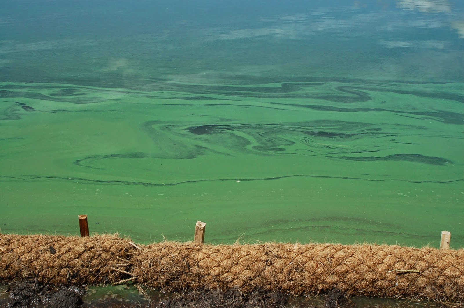
Longer, hot summers combined with large rainfalls washing phosphorus into lakes sometimes create a recipe that results in blue green algae blooms.  These can be toxic to humans and pets.


In July, Carver Lake in Woodbury made the news with the announcement that blue green algae had been detected in the lake. On July 16 RWMWD staff took a sample at Carver Beach. The results of the sample were returned on July 24: Carver was experiencing a harmful algae bloom. Carver Lake Beach goers and other lake users were advised to avoid contact with the lake due to the presence of blue-green algae.


Blue green algae blooms on Casey Lake in North St. Paul were not uncommon
before a 2007/2008 shoreline restoration.  This photo taken as the restoration
began in May of 2007 and you can see the distinctive spilled green paint look.
Blue green algae is often described as looking like pea soup or spilled green paint, but it can take other forms as well. The type of blue-green algae dominant in the sample from Carver Lake -Microcystis is known to produce toxins that can be harmful to pets and humans. Not all blue-green algae blooms produce toxins; however, there is no way to predict if or when a bloom will produce toxins. For this reason it is best to avoid contact and stay out of the water. 


On July 28, the City of Woodbury took two samples at the beach for the actual toxin. Results showed trace levels that pose a low risk to humans and animals. On July 31 RWMWD water quality staff went back out to Carver Lake looking for blue green algae. They couldn’t find the typical paint like algae blooms anywhere on the lake but took an algae sample close to the beach to double check. It came back negative for the toxin producing blue green algae.

To learn more about blue green algae you can find fact sheets and photos on the Minnesota Pollution Control Agency and Minnesota Department of Health websites.
http://www.pca.state.mn.us/index.php/water/water-types-and-programs/surface-water/lakes/blue-green-algae-and-harmful-algal-blooms.html

Blue green algae blooms and mycrocystin
http://www.health.state.mn.us/divs/eh/hazardous/topics/bluegreenalgae.html


So why are there more blue green algae sightings these days? Extreme rain events - like this year's unusually wet June - washed more phosphorous into lakes. Longer, hotter summers cause algae that feeds on the phosphorous resulting in algae blooms. High temperatures coupled with rainfall washing excess nutrients into the water can combine to create harmful blue-green algae in lakes. This type of algae can harm pets, livestock, and even people.


To learn how recent weather problems are making the problem worse, you can listen to an online talk on MPR News by MPCA research scientist, Steven Heiskary who talks about how climate changes impacts the growth of blue green algae and water safety at this link:  http://www.mprnews.org/story/2014/08/07/daily-circuit-climate-cast

The Minnesota Pollution Control Agency advises if you are not certain about algae, don't take a chance.  Stay out of the water and keep your pets out too.

As Heskiary advises, “You don’t have to be an expert to recognize an algae bloom that might be harmful. If it looks bad and smells bad, don’t take a chance. We tell people, if in doubt, stay out — if you are not sure, it’s best for people and pets to stay out of the water.”

August Mystery of the Month - Robobug


It has six legs so it must be an insect…but what crazy insect is clear? And why is it clinging to a cattail? And why is it not moving?


What we captured a photo of here is not an actual insect, but what is left behind - an exuvia - when a dragonfly larva completes its transformation to adult.

If someone mentions dragonflies to you, chances are you will think of the critter with colorful wings and mad flying skills. You may have heard them called “mosquito hawks”, and envision them relentlessly & skillfully reducing the population of those little bloodsuckers. And of course those things are true –but that is not the whole story.

The majority of a dragonfly’s life is actually spent in the water, in the larval form known as naiad or “nymph”. Depending on the species, this life stage lasts somewhere between 2 months and 5 years. Like adult dragonflies, nymphs are voracious predators of mosquitos (in their larval form) but can also be large and strong enough to take down tadpoles, minnows and even small crayfish.

Once the nymph is ready to take that big step into adulthood, it will head towards shallow water and spend some time learning to breathe air. The naiad will then scale the handy stalk of an emergent plant, such as bulrush. Once it has a secure perch, the young dragonfly pushes its head out of its skin (try to imagine that!). If you look carefully at the photo, you can see the hole between the head and the small proto-wings where our model burst through.

As we are only very amateur entomologists we don’t know to which species this guy might belong (if you do know, please share in the comments below!). Whatever kind of dragonfly it is, we like to believe it survived its harrowing transformation and is out there now, doing its best to decimate the population of Minnesota’s “state bird”!

August Pop Up Quiz


In out of the way places or right before your own eyes, there are lots of things going on in our Watershed District that you can miss in a blink of the eye if you aren’t there in the moment or standing by with a camera. So just for fun, try to answer these questions about these recent “happenings.”  Answers below


1. What shrub is Jake Lindeman, Natural Resources intern, watering that just got planted in the new rain gardens installed next to the parking lot at RWMWD this month? 

 
2.  Where in the District is this?  Bonus: What subwatershed(s) and/or cities in the District drains to this structure?


3.  At which church in the District did this Girl Scout troop finish up the planting of their rain gardens this summer?


4.  Where are these Science Technology Engineering and Math (STEM) teachers from St. Paul heading off to explore with Water Quality Technicians, Dave Vlasin and Eric Korte?


5.  How many pounds of algae were harvested from Casey Lake in North St. Paul this past month? 


Answers :

1.  Black chokeberry.


The Beltline Interceptor (located at green star)
manages stormwater overflows from almost 20,000 acres
including parts of 11 cities. Click to enlarge.
2.  This is the Beltline Interceptor Pressure Relief Outlet near the DNR's headquarters near Warner Road in St. Paul. This structure serves as an energy dissipater and overflow for the Beltline Interceptor, to reduce hydraulic pressures and increase the capacity of portions of the Beltline. The Beltline Interceptor serves as an outlet for the Phalen Chain of Lakes and its tributary watershed, Beaver Lake and its tributary watershed, and the local watershed of the east side of St. Paul. The primary outlet of the Beltline discharges into the Mississippi River and this secondary outlet discharges into the channel/wetland system that leads to Pigs Eye Lake, a backwater of the Mississippi River.

3. Our Redeeming Love Church in Maplewood off of Hwy 36 and White Bear Ave.

4.  The Battle Creek water quality monitoring station near the underpass for Highway 61.

5.  56,000 pounds!


Roseville Wins Blue Star Award


Congratulations to the City of Roseville for receiving the Minnesota Blue Star Award for their efforts to protect local water quality.


The Blue Star Award program which was started in July of 2010, recognizes communities that go above and beyond regulatory requirements to keep runoff pollution from degrading their lakes, streams, rivers and wetlands. To achieve a Blue Star Award cities much complete an online assessment of their policies and practices in three core areas: 1) Water Friendly Planning and Preservation; 2) Stormwater Management Standards and Practices; and 3) Stormwater Pollution Prevention.


Lake Owasso's south half lies in Roseville.  This area of the lake is host to a diverse population of
shoreline and aquatic plants, providing excellent wildlife habitat.

Communities that score higher than 60% on their assessment earn a Blue Star Award, and those that are among the top ten highest achievers in Minnesota are listed on the Blue Star Leader Board. The award program is sponsored by a partnership between state agencies and watershed districts, along with the engineering firm Emmons and Olivier Resources and the non-profit group Friends of the Mississippi River.


The city of Roseville scored high enough on the Blue Star Award assessment to: 
 
  • be one of only 18 cities in the state to earn the rigorous Blue Star Award for excellence in stormwater management that has existed since 2010.

  • have the 5th highest score in the state and be recognized on the Blue Star Leaderboard.

  • have the 4th highest score in Planning & Preservation and 2nd highest score in Stormwater Pollution Prevention, two of the three categories that make up the award.